Horseback through the Gila Wilderness – 90% magic, 20% terrifying — Day 3

30 miles in 3 days – Day 3

West Fork, Gila River, Gila Wilderness — early morning

Dawn came softly.  I had just closed my eyes to a deep sky full of stars, and now I opened to a sky just lightening.  Carol’s and Allyson’s sleeping bags were not moving, suggesting that they were both still in the Land of Nod.  Behind me, though, I could hear firewood being thrown onto the morning fire.  Looking past my feet into the trees, six horses moved at a hobbled pace through the grass, heads down and cropping.  They had been released from their ties and sent out to breakfast. 

I resisted the urge to immediately go looking for coffee, instead rolling up my sleeping bag, folding my tarps, gathering my stuff into a coherent pile and taking my saddle pads over to where the saddles and tack were stacked.  My saddle blanket went with me to fireside to provide my seat cushion on the log.

Other than a bright good-morning, Corbin and Joe continued getting ready for our day: building up the fire, filling the coffee pot and the cook pot with water and setting them on the coals to boil, cutting fruit for our breakfast of oatmeal.  Corbin had made a comment the evening before that there’s something therapeutic about sitting and staring into a campfire.  I practiced a little pre-prandial therapy, since there was little I could do to help the preparations.  Eventually, we were all gathered, coffee mugs and oatmeal in hand and the day properly begun.

As we sat and compared nighttime noise stories – I had heard a Great Horned Owl and wondered if anyone else did – occasionally either Joe or Corbin would count to six.  If they only counted to five, Corbin would go in search of the missing horse.  This was something I had observed previously while in camp. Even though hobbled around the front feet, a horse can make quite a bit of headway, often ranging out of sight. He would encourage them back, usually with little trouble.  His horse, Biscuit, had an investigative nose.  She was often poking around the food stores, poking at Corbin’s bedroll, or at anything else she found interesting.  Poor Smoke, on the other hand, had little patience for her hobbles. This morning, as she tried to move forward, she stumbled over her front feet, sat back on her haunches, and stood in a quiver.  Joe looked at her and just shook his head. When I curried and cajoled her later, I noticed that she had a little scrape on each front foot, just above the hoof.

Well fed, once again, and it was time to pack up for our last day.  As we were ready to leave the fire, Corbin – or was it Joe? – told us that not long after we left the camp, we would come to a part of the trail that runs along on the side of a steep hill for about 1/4 mile.  Looking right at me, he said, “But Smoke is an old pro at this.”  Well, yes, maybe she is.  But I surely am not. 

Oy vey.  And here I thought the rest of our ride would be a stroll along the river, with the terror of yesterday’s Hells Hole put behind us.  Well, as an old country song goes, “If you got your confidence with you, you can do anything.”  We saddled up, mounted up, and headed out on our last 10+/-miles, including that 1/4 mile of hillside. I started working on my confidence right away.

Sure enough, it wasn’t long before the trail trended upward along the side of a partially wooded-partially rocky slope.  It wasn’t steep enough to switchback and we weren’t climbing to the top. Rather the trail continued laterally.  However, the challenge became obvious quickly.  Most of the hillside was composed of talus slumped down from the top. Here was a difficulty for the horses that they didn’t have to navigate coming down Hells Hole trail.  The trail was etched in across loose rock that clinked and slipped under their feet as they minced their way along. And then there was about 8 feet of slickrock slanted downhill to cross.

I engaged in both an out-loud and an under-breath conversation getting across that quarter-mile.  “Watch your feet, girl.  Ok, Smoke, be careful. You can do this.”  Alternating with, under my breath: “f**kohf**kohsh*tTrust Your Horseahsh*tTrust Your Horseahf**k.”  “Good Smoke, watch your feet, girl. Take it easy, Smoke.”   Well, she did and Joe, who’d been leading on Jet, with Kissee tethered to him, was waiting on the now-wooded and pine-needled gentling slope to give me a thumbs-up. I grinned and announced the obvious, “I made it, white knuckles and all.” Allyson, riding behind me, had heard my overt exhortations to Smoke, but fortunately not my self-talk.

The West Fork Gorge is stunning. The walls are crenelated and hoodoo-ed. The river slips between the walls, sometimes pushing the trail up against the foot of the cliffs, sometimes forcing the trail up and over little ridges.  A lot of rock on the river edges and in the river bed, rock of not insignificant size.  Some of the riversides are a drop from a level trail, down a rocky slope and up on the far side.  Smoke picked her way carefully down the rock, stepping between rocks in crossing the river and jostling up the far slope.  Occasionally, her foot would step into a hole, pitching us forward. I did a lot of standing in my stirrups – stand-and-lean-back going down and stand-and-lean-forward to get up the other side. I peeked at the walls and spires of the gorge as much as I could.  We stopped at several river crossings to water the horses and took advantage of those moments to pull out cameras and make record of the beauty and drama. This was part of the magic I didn’t want to miss.

Corbin on the trail along the river in the West Fork gorge
Carol takes a picture while Raider eyes another snack.
Last lunch before leaving the Wilderness

Eventually we encountered people.  And dogs. And noise.  Backpackers setting up camp under a rock overhang.  Hikers with two loose dogs; they held the dogs as we walked by. More hikers, casual as they stepped off-trail.  Just as we were plunged into the vibrant fall colors and through the flood plain covered with Chamisa as we left the Gila Cliff area, we rode back into that environment after crossing the boundary out of the Wilderness.

Leaving the West Fork gorge and into the Gila River flood plain.

Coming into Woodys Corral, we were met by Joe’s support team with their trucks and trailers.  I got my last dismount assist, took Smoke to a rail and tied her up.  I unloaded my personal gear and put it in Carol’s car.  Then, I unbridled Smoke and with Corbin’s help, pulled off the saddle, the saddle pads and blanket, saddle bags, rope and all the accoutrements of the trail and took everything to Joe’s truck. Time to say goodbye to Smoke.  I rubbed her muzzle and scratched her forehead and down between her eyes.  I reached under her chin and gave her head a hug.  Another muzzle rub and another attempt at a head-hug.  I guess Smoke isn’t a hugger; she tossed her head up and away from my attention. So, ok, I get it.  Well, bye, Smoke.  And thanks.

My selfie on Smoke

Horseback through the Gila Wilderness – 90% magic, 20% terrifying — Day 2

30 miles in 3 days – Day 2

Prior Creek to Lilley Park. Hells Hole Terror. Along the West Fork Gila River

The half-moon set sometime early in the night.  The temperature dropped and my head got a little cold.  Solved that by pulling my fleece vest from my “pillow” stack of clothes and wrapping it around my head.  Peeking through the armhole of the vest, I gazed up at the star-struck night sky.  Saddle pads do not a soft mattress make. Hips sore from being launched onto and sliding off a saddle do not an easy rest make. But the stars made up for a lot. I must have fallen asleep because suddenly, it was dawn. 

The fire was crackling as Corbin moved around in front of the flames, throwing firewood on.  Horses were released from their overnight ties and hobbled, turned out to graze on the sparse grasses. I got dressed in the confines of my sleeping bag, pulled on socks and shoes and rolled up the bedding. Stumbled over to the fire to find my cup left on a rock and made a cup of instant coffee. No creamer but mocha/chocolate powder made a sweet substitute.  Rocks were fireside patio chairs, topped with saddle blankets for cushions.  Breakfast was foiled and laying on the coals to heat.  Red chile beef tamales, bread and fresh fruit.

We didn’t hurry breakfast, taking time for coffee and a bit of conversation even though we had about 10 miles over 5 or so hours of riding.  What’s the trail and schedule for today.  What is our destination. Where will we find water for the horses and for ourselves. And for me, what terror awaits.

I went to find Smoke, who was hobbled and befuddled.  I tried to lead her back; she stumbled and mumbled.  Once I took the hobbles off, she was happier and came along peaceably. We curried, saddled and packed. The packhorse, Kissee, was loaded and strapped.  Breakfast fire was extinguished.  We were up and off. 

Smoke is loaded and ready. Carol finishing up with Raider
Allyson preps Young Gun

We had several miles of quiet, peaceful Ponderosa pine forest to travel along the Prior Creek drainage.  Prior Creek was full and running, and the horses slurped water up through their “straws.”  Upstream a little further, we dismounted, let the horses graze and filled our own water bottles at the spring source.  Joe and Corbin trusted the spring water and only filtered it through their kerchiefs into their bottles.  The three of us took advantage of Carol’s filtration system to remove all doubt, filled 3 water bottles each for a total of about 6 liters.  This water had to last us until tomorrow.

I rode second in our line, behind Corbin in the lead.  Behind me, I could hear Carol, Allyson and Joe in conversation, though I could not hear enough to follow.  A word or phrase but not a thread.  I let that go and just rode, staying present and holding in memory my surroundings, my experience of Wilderness, and my body’s movement in concert with my horse. Looking at the Ponderosa forest, seeing an owl take silent wing from a low-hanging branch. Knowing in the moment that this would be one of the highlights of this trip.

We cut across from Prior Creek trail to Lilley Park trail, somewhat reversing direction and headed for our lunch stop.

Hells Hole. There is only one way to get from the plateau to the river and that is down.  Hells Hole is the point Joe chose to make that descent.  It is called Hells Hole because when you are on the edge of it, you can’t see the bottom.  One and one-quarter mile down the side of the gorge.  A narrow trail switchbacking along a sheer face and definitely no gentle fall-away. And me with my fear of heights and edges. Compound that by being several feet off the ground on a horse and not in control of my own fear – um, feet.

Of course I knew it was coming.  Joe told us the route well in advance and I had the topo map.  He had ridden the route a couple of weeks before to check the trail conditions and water sources and confirmed that even he was a bit nervous going down; he assured me I could walk if I needed to.  From our lunch stop to the edge of the abyss, I repeated my mantra: “Trust your horse. I can do this.  Trust your horse. I can do this.”  I got as far as the first switchback, looked down into an eternity of empty space and called out, “Joe, I can’t do this.”  We stopped the horses, he got me down off Smoke, neither of us went over the side in the process.  For the next 1/2 mile or so, I walked at a horse’s pace behind Joe, the pack horse and Smoke, followed by Allyson, Carol and Corbin on their horses.  Joe walked too, to slow the pace enough for me to keep up.  I could hear the breath of Allyson’s Young Gun at my back and her frequently calling “Ho” to slow him down.  Finally, I could see trees and a slight leveling of the trail.  Joe stopped the horses, came and boosted me up on Smoke and I felt, whew, we’re almost there.  No.  We rode the trail for a few hundred yards around several more switchbacks and then out onto open edges again.  Back off my horse, back on my own two feet, down another 1/2 mile at horses’ pace. Until finally, the river was in sight – and a most wonderful sight it was. I got back on Smoke, to let her do the walking and to rest my burning thighs.

West Fork, Gila River, Gila Wilderness

We dropped into the river, literally, crossed over and continued for a mile or so to the campsite Joe had planned for the night.  Repeating the routine of the night before, we unsaddled and hobbled the horses, staked out sleeping areas, gathered firewood and started the dinner fire.

Joe and Corbin — bedrolls
Campfire 2nd night — one cook pot and one coffee pot.

This night, the sun set on the cliffs and hoodoos of the West Fork gorge.  We sat by the fire later into the night, talking and sipping hot tea.   I found a spot for my sleeping bag that had a nice little concave area, perfect for resting sore hips. I crawled into my sleeping bag with my saddle blanket on top for warmth, wrapped my head in my fleece vest again, and watched the stars brighten until I found sleep. 

West Fork, Gila River Gorge, Gila Wilderness

This is Natural. This is not.

Here are two pictures, taken a very short distance apart on a trail along the Gila River.  Which belongs?  Which does not?

Fair warning: I am going to rant a bit. Live up to that tag line I believe in: A Public Lands Advocate.

I have been hiking and camping our National Forests, National Parks and National Monuments for the last several years.  In fact, that’s what motivated me to start sharing my stories and photographs.  Mostly, my stories are about my personal experiences, my photographs share my awe and wonder.  Occasionally I lapse into “trainer” mode. I try to avoid “preacher” mode.  Today, I’m all of those: storyteller, trainer, preacher.

I am wedded to the Gila National Forest, including the Gila River because that is my door-step. I have found my solace and soul here during these last difficult months when we are socially distant from our friends and family, not traveling, zoom-stuck and zoom-weary. If you’ve read any of my stories this year, you have traveled these trails with me, my dog and a friend or two.

It seems we are not the only ones moving into the Forest and along the River. Folks are coming from neighboring states and from farther away. Sadly, many who are finding their way this way are not here for the quiet and solitude that a Wild and Scenic River or a Wilderness experience can offer. They come, rather, in clusters and groups and occasionally, hordes.  And it’s not so much that folks are coming. These wildlands and waterways are, after all, open to all of us; we all own these public lands.  It is what folks are leaving behind when they go.  Here are the most recent pictures I’ve taken of the trash that they’ve left.  Trash that includes human waste (I blurred one part of one picture that was explicit).

And here are some excerpts from recent news coverage in our local paper of what others who, like me, are passionate about our wildlands, have found—and removed.

She pointed specifically to trash littering the sides of forest roads, recreation areas, and stretches of the Gila River. [She] invited the Daily Press to visit the Mogollon Box Day-Use Area last Friday, where about 150 to 200 people were posted up in a variety of groups, both large and small — but nearly none below the state-mandated size of five or fewer.

…half of the 20 people we spoke to were from elsewhere. Ohio, California, Arizona and Texas were a few of the states folks visiting the Gila last Friday called home.

…10 pounds of trash that [she] picked up during a 30-minute walk… Toilet paper and unburied human feces were seemingly everywhere on the riverbank, just yards from two sets of bathrooms maintained by the Forest Service.

Besides the obvious problems of trash and waste ruining the aesthetics of the outdoors, and noise pollution disrupting the peace that at least some visitors are seeking, there’s the issue of wild creatures getting used to trash as a food source.

What happens when people leave garbage…is that skunks, bears and other critters habituate to it. Having those animals getting used to being around people — that’s cute to some degree, but only until there’s a bear jumping on someone’s car.  Silver City DailyPress, 6/15/20

If you are escaping to the Gila National Forest.  Or to any Forest. Or Park. Or Monument. Or Bureau of Land Management wildland, here are the guidelines for Leave No Trace.

7 Leave No Trace principles to minimize impact:

Plan ahead and prepare

Travel and camp on durable surfaces [Note—Respect USFS signs for no motorized vehicles, including ATV, UTV and dirt-bikes.]

Minimize campfire impacts [Note–open fires are currently forbidden in the Gila National Forest]

Leave what you find

Be respectful of other visitors

Dispose of waste properly

Respect wildlife

Please be a Public Lands Advocate.  The animals depend on you.  The rivers depend on you. The forests depend on you.  I depend on you.

Upper Gallinas/Railroad Canyon by Halves

First, let me locate us on the map.  We are in the Black Range of the Gila National Forest, just shy of Emory Pass.  Here is the full hike loop from NMWild’s new Hiking Guide. While the trail loop is a total of 10+ miles, we didn’t go the distance.  We hiked up past the juncture shown on the map of Gallinas and Railroad Canyons, taking the Railroad Canyon trail to the right, to a not-shown juncture with East Railroad Canyon trail.  That’s about 2 ½ miles from the campground/trailhead or about 5 miles round trip.

Every summer, when my favorite trails get too warm – or rather, when the summer temperatures are too warm for my favorite trails at lower elevations and exposure, I “head for the hills.”  On this day, a friend, Dog and I were grateful to leave an already 70°-something morning at 7:30 am to arrive at the trailhead at something closer to 60° about an hour later.

20200526_115450-1One half of the canyon follows Gallinas creek (Guy-ē-nas).  The creek was running full, though not as full as it would have been earlier in the Spring with snow melt and will be again with monsoons.  The trail crossed the creek any number of times but given the lower level of the water, the stepping stones were raised and dry.

We were canopied by Ponderosa pine and mixed hardwoods, mostly oak.  Along the creek, willow and coyote willow hosted Robins, Hermit Thrushes and smaller, shyer birds. Monkeyflower and lupine bloomed in the moisture among the rocks and in the duff under the pines.  Bird song followed us though the canopy hid the singers. We were fortunate enough to see Red-faced Warblers and Painted Redstarts darting among the Ponderosa boughs.

One half of the canyon is Empire-sized stone shoulders and wind-and-rain-carved hoodoos.  In the lower part of the canyon, we only glimpsed the heights through openings in the dominant green.  As the trail and creek climbed the canyon, though, where the oak thinned and Ponderosa mixed with fir trees, we had views of the massive rock sides.  We passed large boulders balanced on each other.  Our trail zigged, switchbacking up rocky slopes and zagged back down to the creek and a respite of tree cover. 20200526_124751-2 
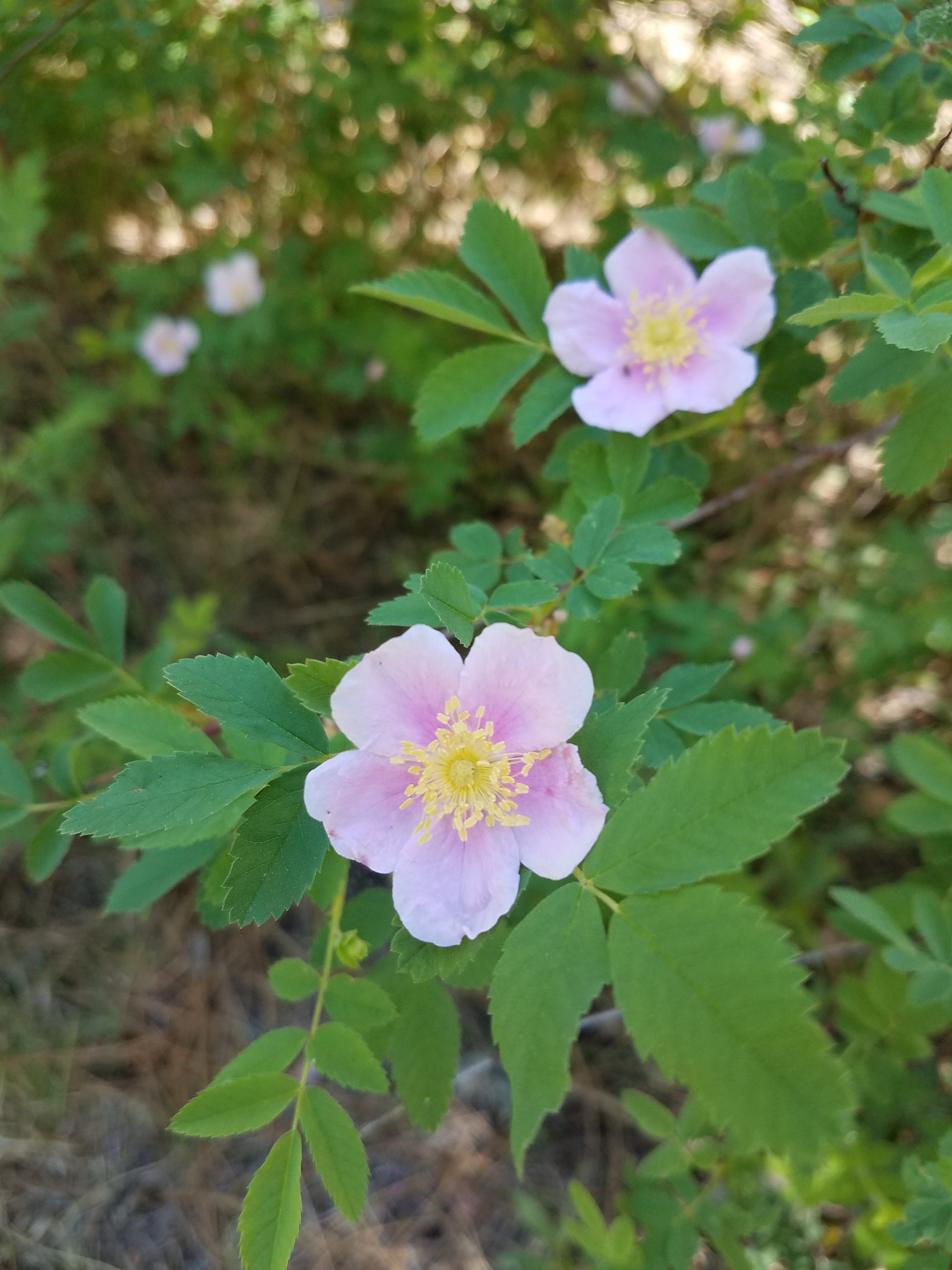
Here, we found wild rose, delicately scenting the air. On the sunnier side of the trail, there was cactus blooming and other wildflowers providing color.  Banana yucca held up cream-colored stalks on far rock slopes.

One half of the canyon burned in a major wildfire that tore through the Black Range a few years go. The higher we climbed up the canyon, the more the burn scars became apparent.  We walked through patches of standing forest into patches of stark burned trunks.  There were places where we could see the fire behavior had rolled through the underbrush leaving trunks of healthy Ponderosa blackened up 10 or 12 feet.  This is as it should be in a “good” wildfire.  Another hundred feet and we’d step into a clearing created by a hot spot that crowned and destroyed the pine and fir. A natural post-fire rehabber, the New Mexico locust covered the hillsides, just now fully in bloom.

And one half of the canyon is deeply shaded glades surrounding pools and riffles of the creek.  On the way back down the canyon, as the rising heat of the day hurried us below the rocks and scars back to tree cover, we stopped for lunch to sit on rocks, dangling our feet over the water as it burbled below us. Dog stood chest deep, slurping and dribbling cool water, then climbing on my rock to lean on me and request a share of my apple and then another and another.20200526_102406-1

It was a one-dog night!

Black Canyon map

Black Canyon is carved east to west between the Aldo Leopold Wilderness and the Gila Wilderness.  It connects the Black Range and the Mogollons in the Gila National Forest, a 3 million acre respite in southwestern NM.  It’s remote, as any spot in the wilderness should be. There is one road, North Star Mesa Rd, that winds and twists and hiccups up the sides of ridges, runs along the tops of mesas and ridgelines, and slithers switchback down into a series of canyons.   A high clearance vehicle is de rigueur; AAA isn’t about to come to the rescue of a low-slung sedan that scraped its oilpan loose on the rocks in the road. Washboarding is unavoidable because the road is too curvy to skateboard over the washboard ridges at speed.  Since there’s no there, there, sliding across the black ice of washboard gravel can spin you out over the edge of the hill and down several hundred feet.

But it’s worth the trip.  The campground is set along a perennial stream, shown on the Gila National Forest map without a name.  At the entrance to the campground from North Star Mesa Rd, there’s a dam that plays a part in the project to reintroduce the native Gila Trout.  Trail #94 starts at the lower end of the campground and follows the creek for a while, then peters out.  Because it’s a challenge to reach, and the road isn’t one typically used to get from here to there, the campground is lightly used.

Our wilderness inventory tribe hasn’t camped together for a year or so, because our inventory work has finished and the results fed into the Gila’s forest planning process.  It was time to get out and reconnect with each other and with wild places, to enjoy good food, good wine and lots of conversation.  Our group went in for a two-night weekend. This time, I brought my dog.  She’s a 4 year old 55 lb half chocolate Labrador Retriever and half Black Mouth Cur, more hunter than retriever and all muscle and curiosity.  She’s an affectionate dog, a well-mannered dog.  I can brag because I adopted her this way, and take no credit for her good behaviors.  She’s never camped before and I wondered how she would fare in the woods with all those wild smells and sounds, and how she would sleep in a tent.  I took her collapsible kennel and bed so she’d have something familiar come bedtime. When it was time, she didn’t hesitate to go into the tent, although the zipper door was a bit puzzling to her.  Nor did she hesitate to curl into her kennel, take her bedtime treat and settle down.  And I cozied into my sleeping bag and settled myself down.  Until about midnight.  I woke up reaching for my extra blanket, pulling it up over my sleeping bag.  It occurred to me that if I was that cold, I wondered how the pup was doing, so I reached into the kennel to check.  Sure enough, she was in a tight little ball, shivering.  After trying unsuccessfully to cover her inside the kennel with a jacket, I gave up and invited her onto my cot and into my sleeping bag.  A happy girl she was, snuggled up and hugged. It was about 34° when we woke up at dawn; no wonder we were both grateful for the other’s heat.

The next night, I borrowed a comforter from a friend who had the luxury of a camper.  We thought, if we covered the dog’s kennel with the comforter, it would help keep her body heat in and ensure a warmer night in her own bed. That worked and we slept well until about 3 am.  Once again awakened reaching for my blanket, I checked her in her kennel under the comforter, and once again, she was balled up and shivering.  So, once again, invited into my sleeping bag and curled in my arms she was. At dawn, my fellow campers, bundled in puff jackets, hats, scarves and mittens against another 35° morning, greeted me over coffee, teasing about a 1-Dog night.

My dog and I took a bit of a walk on the dirt road that ran through the campground. On the top of a hill above the creek, we were attracted to movement in the creek below.  She went on alert and I peered over the edge to see what had her so focused.  A group of four or five mature javalina were working their way upstream.  It became obvious that they were very aware of the dog. Still, they moved no more warily for her distant presence, but did keep one eye uphill.  She was pointing with focus, but showing no intent to rush down the hill to confront the animals.  Good thing.  One dog and one or more javalina, and the javalina will always come out on top.  They are non-threatening when left alone, but vicious if challenged.  I had her on leash, but that would have mattered little if she really wanted to course downhill after the javalina; she could have pulled the leash right out of my hand and me onto my nose. We turned back to the road, only to confront a black bear coming down hill directly toward us. I saw the bear a split second before the dog did, and so was prepared if she decided to charge.  Instead, she saw the bear and froze.  That gave me time to call to her loudly and back us both up, away from the bear.  Bear saw us, and, halting with a paw raised for a next step, studied us for seconds that seemed like minutes.  I continued backing us slowly and talking, which gave the bear time to decide it didn’t really need to get down to the creek just at that moment, and to turn and lumber back up the hill.

I wonder if the dog will expect black bear encounters and sleeping bag snuggles on every camping trip from now on.  Probably. Pumpkin.5-14-19 (2)


The earth is flat — until it’s not!

We cross a saddle in a ridge from the trailhead and pass into the Gila Wilderness. Lying before us is almost three miles of flat mesa.  Walking across that wide meadow of grasses and wildflowers, we follow a narrow trail, pitted by mule and horse feet, rocky and muddy thanks to impact of monsoonal drenching.  The views are expansive from the slight rises, and intimate in the dips. I can tell we are approaching the edge of nothing when I start seeing, instead of the trunks of Ponderosa, the crowns.  Through the crowns, a blue haze of air. The trail tends away obliquely, making me wonder how far this mesa goes and when it will drop away from under my feet.

Old Truck on Aeroplane MesaWilderness isn’t empty, not of people and not of things.  To the right of the trail, silhouetted against the sky is a relic: a 40’s era truck driven out to the edge of the world and abandoned, fodder for curious hikers’ wonder and speculation.

Then we are there, where the flat becomes vertical. Approximately 1500 feet of rocky switchback trail lies between mesa and river bottom.  Meadow and Gila River.2.ed
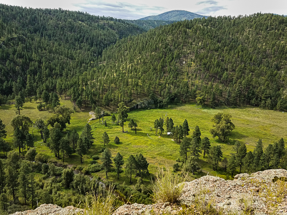
There’s an overlook where we see our destination, a river-side meadow specked with the white kitchen tent secluded under a clutch of pines. The scary aspect of the view is that we have to get down there. As we pick our way among the trail rubble, we hear the mules coming with our weight of tents and bags.  The outfitter calls down to us, “Move to the downhill side.  Mules spook if a critter is above them.  Is that you behind a bush? Move out where the mules can see you.”  I step down and out of the way, and watch the outfit step on by us, more surefooted than I am, for sure.  Then, we work our way on down to level ground, off the sun-exposed cliff-side and into the shade.

Our first night around the campfire and under the Milky Way.  There’s a flicker on the far horizon that isn’t city-generated.  By mid-night, planets, stars and campfire are overwhelmed by a strong storm cell that parks overhead for the next several hours.  Lightning flashes my tent-sides bright, and thunder rolls overhead and on down the valley.  The storm is centered right overhead and the ground vibrates under my sleeping mats.  What’s to do except lie awake and in awe.  Saturday morning, we stand under the kitchen tent, sharing storm stories, drinking cup after cup of coffee and looking anxiously for spots of clearing overhead.  Suddenly, Lightning-struck tree.1

WHAMBOOM — a lightning strike about a football-field distance away.  We all duck and, on straightening, see the smoke and steam rising from a single pine tree on the edge of the woods at the far side of the meadow.  It still stands, but has been split in two and its roots boiled up out of the ground around it.  Splinters scatter on the newly-bared earth.  I’m not sure any of us have ever been that close a witness to the power of lightning’s electric impact.  Over the course of the morning, we go in ones and twos over to look at the result: at the split tree, the splinters, the upheaved earth and the scorched ground scar.

It’s late summer and in the meadow, along the river edges and under the pines, the earth explodes in bloom.  We count perhaps two dozen species of wildflowers, all native because how else would they be, out here in the wild.  Purple, orange, blue and more blue, seemingly a dozen shades of yellow, we wade hip-deep in color.

A diversion is suggested: a hike up river a mile or so to see a beaver dam.  Beaver are coming back on the Gila; they are cutting trees, dragging them distances and lacing them across the river to catch up and slow down the flow.  We find the dam stretching across most of the river’s width.  A cheerful rush of water through the branches, a pond held up behind and extended wetlands.  While we stand on the edge, a ripple surfaces and crosses the pond.

The day comes to leave the magic meadow retreat.  Roll the sleeping bag and mats, drop and pack a dew-wet tent, sort my day-pack to its lightest possible weight and sip a last cup of camp coffee.  Slowlyslowly climb up the cliff from river to mesa; take a last look over the edge at the kitchen tent, to be broken down by the outfitter the next day; face forward the long trail across flat earth and over the ridge to the trailhead.Down from the Saddle

There are additional images on my flickr page, linked below.